


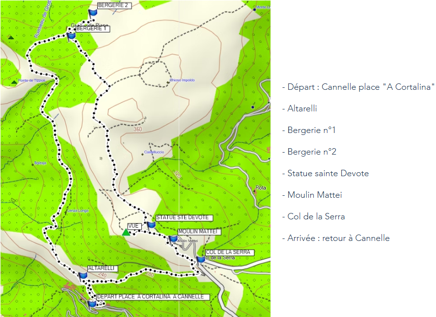
START: from the square in Cortalina to the hamlet of Cannelle
CIRCUIT: From the square in Cortalina, take the small concrete lane that initially becomes a dirt track and will lead you to the last house at the top of the hamlet of Cannelle, at a place called Altarelli. Continue straight towards Grotta alle Piane for about 150 meters and you will reach the Pozpella viewpoint. Continue along the path, crossing the well-shaded undergrowth of Borgone and Bolzaja, where you will see cuidoni (stones planted vertically in the walls that were used to create hedges around the plantations to protect them from the wind). Then you will descend and cross the Tizzioli stream before climbing back up to the Vitelaggio viewpoint. Turn right at the pass and descend towards the first sheepfold of Grotta alle Piane. If you wish, you can go to the second sheepfold: to get there, take the path that passes to the right of the first sheepfold and follow it for about 200 meters and take the same path to return to the first sheepfold. Continue your walk by taking a left-hand uphill path marked with cairns (in addition to the red markings) that you will follow until you reach a dirt track. Turn right onto the track towards the Mattei mill and follow it for about 1 kilometer. About a hundred meters before the Mattei Mill, turn right before the statue of Saint Devota (which you can see from behind) to reach a beautiful viewpoint: pass by a huge pile of stones, descend about thirty meters, and climb up to the small promontory on the left, from where you can admire the magnificent view overlooking the port of Centuri. Then, retrace your steps, pass in front of the statue of Saint Devota, and go to the Mattei Mill. Descend from the Mattei Mill to the Serra Pass via the dirt track (you will find information signs along the way). From the Serra Pass, descend towards Cannelle, first taking the dirt track on your right for about 300 meters, then a path that branches off to your left and will lead you to Altarelli. Reach the square in Cortalina by returning to the dirt track, which eventually becomes a concrete alley.
APPROXIMATE DISTANCE: 7 KM (including the detour to the second sheepfold)
APPROXIMATE DURATION: 3 HOURS
NOTES ON THE ROUTE: The route is marked in red and the trails are of fairly good quality (except for a rockfall on the descent to Cannelle), but the descents can be slippery after rain. It is therefore advisable to wear hiking shoes with non-slip soles. You must follow the safety and environmental protection guidelines, which are outlined on the town hall website. This walk is not recommended in strong winds.